Yellow code for torrential rains and vijections. Map of targeted zones / how will the weather be in Bucharest


Storm. Photo source: dreamstime.com
Meteorologists have issued a bad weather alert that enters into force on Tuesday, April 22, from 12 o'clock, targeting several areas of the country.
ANM has published a map with the areas affected by the yellow code of atmospheric instability until Tuesday evening, at 23.
In the mountain and submontane areas, in the north of Oltenia and Muntenia, in the south and east of Transylvania and in the south of Banat there will be periods with accentuated atmospheric instability, according to meteorologists.
This will be manifested by torrential showers, electric discharges, short -term intensifications of the wind and isolated hail falls and vigils.
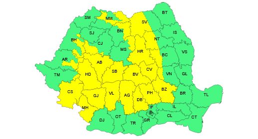
In short intervals of time or by accumulation the quantities of water will be 20… 25 l/sqm and isolated over 40 l/sqm.
Such phenomena will be reported on restricted areas and in the rest of the territory, according to the National Meteorological Administration.
On Wednesday, April 23, the weather will be unstable especially in the west, southwest and center of the country, as well as in the mountain and submontane areas.
How will the weather be in Bucharest
In the capital, on Tuesday, between 12-23, the weather will be particularly hot for this time. The sky will be variable, but in the evening hours the probability for showers, electric shocks and short -term wind intensifications will increase. The maximum temperature will be around 26 degrees.
Photo source: dreamstime.com