What extreme weather phenomena in the region of Moldova show us. Specialist: “It is essential to update construction standards”
The strong wind that made perish in Moldovaleaving roofs ripped off, trees down and, tragically, lives destroyed, is just one of the increasingly common signals of a changing climate. At the same time, the sudden changes in temperature – from unusually warm days to severe cold – raise questions about the weather patterns we were used to. To better understand what is actually happening, we spoke with climate change specialist Alex Trandafir. He explained to Adevărul how the extreme phenomena in Moldova were possible, but also what to expect in the future and what measures should be taken to adapt to the new climate reality.
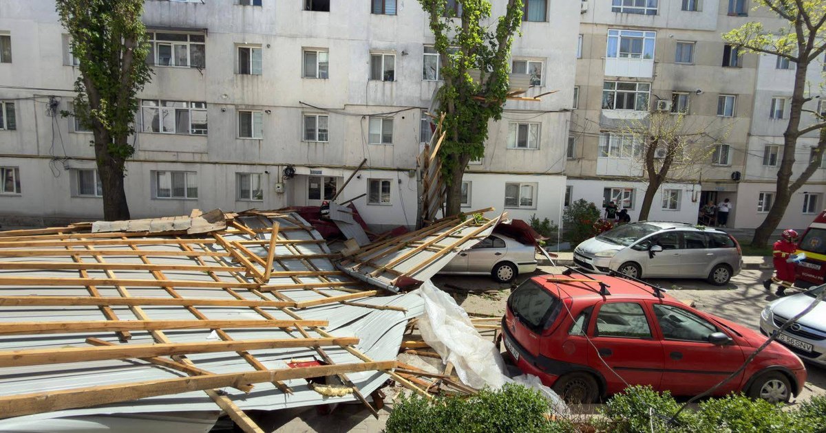
PHOTO Facebook/Meteoplus
The truth: What was the basis of the recent extreme phenomena in Moldova and what factors contributed to their intensity?
Alex Rose: The recent weather events were caused by a sudden advection (descent) of cold air that quickly replaced a warm air mass previously present over our region. Everything happened with the passage of a cold front associated with a cyclone from the Russian Plain.
The large temperature difference between the warm air in front of the front and the cold air behind it generated what can be called a “gradient wind”. At the same time, the atmospheric pressure differences between the cyclone and the anticyclone further amplified the wind speed.
An important role in this whole equation is played by the jet stream, which is a wind that blows strongly in the upper troposphere and acts as a barrier-cordon between the cold polar air and the warm air. When it becomes more wavy or weaker, it allows cold air to penetrate to lower latitudes, generating sudden changes in temperature, as happened in the present situation. Basically what we saw was the combined result of several factors: high thermal contrast, large pressure differences, the intensification of the jet stream and the particular dynamics of the cold front.
Typically, such situations are accompanied by significant rainfall. However, in this case, the cold front had a “dry” character, and the air masses involved did not favor the development of convective clouds (storms) that would generate significant precipitation. Thus, the dominant phenomenon was extreme wind, not rain. In terms of the climate context, these episodes are not new, they are part of the natural variability of the atmosphere, but there is very clear evidence that, in the context of global warming, extreme weather phenomena are becoming more frequent and more intense, even if not all cold fronts produce such an impact.

Alex Trandafir, climate change specialist
The truth: Can we expect more episodes like this in the next period?
Alex Trandafir: If we look at the statistical analysis of weather and climate data, they suggest that the frequency and intensity of extreme phenomena are increasing in most regions of the world, with differences in character from one region to another.
Compared to other areas where significant decreases in annual precipitation levels are observed, in the Balkan area and Romania it seems that the total level remains the same, but changes are seen in the way precipitation is “distributed” throughout the year. In practice, longer periods of drought are observed, followed by short periods in which it seems that the atmosphere “fills the void” through extreme weather phenomena, namely storms and floods.
Therefore, it is reasonable to expect that such situations, characterized by sudden and violent changes in weather, will become more frequent in the future.
“Applications can be misleading. It is important to follow the official warnings”
The truth: We could better anticipate such phenomena in the future? What limits are there in forecasting?
Alex Trandafir: Forecasting ability has improved significantly in recent decades, but there are clear limits. Meteorologists can anticipate, based on climate indices such as the North Atlantic Oscillation or the Arctic Oscillation, the periods when cold air intrusions or atmospheric instability are more likely, as in the present situation. However, the exact data of the phenomena (wind speed, temperature, location) can only be accurately estimated in the short term, usually between 48 and 72 hours in advance, sometimes even only 24, when the weather-climate patterns are uncertain. Usually, this limitation is related to the chaotic nature of the atmosphere and the internal variability of the climate system, which introduces significant uncertainties into the models.
However, the integration of artificial intelligence into weather models is beginning to reduce these limitations. They can compile a much larger volume of numerical data on the movement of air masses, and implicitly, lead to more accurate forecasts and longer forecast times.
I believe that as climate change is increasingly felt in our lives, we would do well to integrate as much weather forecasting as possible into the way we organize our activities. If in the past maybe if we knew it was going to rain and an umbrella was enough as a measure taken, now maybe we should go to the next level and check other data, not only the rain “icon”. Apps can be misleading if we don't check the data carefully. And it is extremely important to follow the official warnings issued by ANM.
Violent storms in Turkey: At least five people died and several were injured
The truth: We have also seen large temperature variations in recent months. It suddenly goes from very hot days for the calendar date to colder than usual temperatures. What is the explanation in these situations?
Alex Trandafir: Sudden temperature variations are the result of the same atmospheric dynamics: the rapid movement of different air masses. When the jet stream becomes unstable, it allows rapid alternation between warm air and cold air. Thus, rapid transitions from temperatures above the average of the period to significantly lower values can occur.
The truth: Are these variations a clear sign of climate change or just temporary episodes?
Alex Trandafir: Here is the key. Each individual episode is essentially a normal weather phenomenon, part of natural climate variation. However, when we look at long-term trends, we see that the episodes are becoming more frequent and more intense, which is a clear signal of climate change. Thus, these episodes are not isolated anomalies, but part of a changing climate context. The problem is, however, that the atmosphere is so complex that it is difficult to establish exactly quantitatively the link mechanism between the average heating of the air temperature, the jet stream, the movement of air masses, respectively the extreme weather phenomena. Because this heating acts as a whole but also individually, on each element in the equation. In English this term is found in researches like and “compound effect”. One could translate “compound effect” in Romanian, because in fact all the elements influence each other, and compose the final result/impact.
“An integrated adaptation approach is needed, including resilient infrastructure”
The truth: How are these changes affecting ecosystems and what adaptation measures are most urgent?
The impact is significant and varied. In agriculture, sudden changes in temperature can affect crops, especially when warm periods are followed by frost, as in the present situation. In infrastructure, strong winds can cause significant material damage, and even human loss, as we have seen, again, in the present situation. Ecosystems are also affected, as many species cannot adapt quickly to extreme variations.
In terms of adaptation, it is essential to update building standards to cope with new climate conditions, and not just on paper, but also in practice. Urban drainage systems should also be upgraded to better manage rainfall events that lead to street flooding in cities and towns. Moreover, cities must invest in integrated solutions. And these are not complicated. The best examples are green spaces that can reduce both the effects of heat waves and the urban heat island, as well as the risk of flooding, through “buffer” areas with specially chosen vegetation to absorb extreme precipitation.
These integrated “intelligent renaturation” solutions have been applied for a long time on the European continent, including outside the cities, where there are problems with floods, for example. And, of course, and vice versa, the creation of collecting basins and the implementation of smart irrigation solutions. The bottom line is that in the long term, an integrated adaptation approach is needed, including resilient infrastructure, adaptive urban planning and nature-based solutions.
2025, the fourth hottest year on record
The truth: Given the unpredictability of the last few months, what can we expect in the summer?
Alex Trandafir: There are indications that, globally, we could face a “Super El Niño” episode.
This climatic phenomenon involves the warming of the waters of the equatorial Pacific and has effects on the global atmospheric circulation, including on Europe and Romania. In the past, strong El Niño episodes have been associated with record temperatures and extreme weather events, including in Europe, as we saw for example in 2023 (the devastating fires in Rhodes, floods in Greece, etc.)
A clear and increasingly frequent pattern is the alternation between prolonged periods of heat and drought and short but intense episodes of storms and precipitation, which we will most likely see again soon as we soon enter the warm season.
Alex Trandafir has a degree in Geography and a master's degree in “Climatology and Weather-Climate Adaptation” at Loughborough University in Great Britain. He works in the field of environmental consulting, within Enventus.EU, a company specialized in climate risk analysis and the integration of adaptation solutions in infrastructure projects.
Throughout his career, he has supported organizations in the development of climate change adaptation strategies, collaborating with institutions such as the National Museum in Liverpool. In parallel, he is involved in applied research at the Integrated Climate Center, contributing to the development of innovative solutions for intelligent climate adaptation.