GPS signal jamming (jamming, spofing). Why this technique is increasingly striking European aviation

GPS is the American GNSS (Global Navigation Satellite System) system. His satellites in the medium orbit send signals of very low power. The weakness of the signal after reaching the ground makes it It is easy to suppress a stronger emission from the earth (jamming)and in a more sophisticated variant – to impersonate a real signal and “inject” false positions about positions (Spoofing).
In Aviation, GPS/GNSS is part of a redundant navigation skeleton, and pilots have at their disposal, among others INS (INERTIAL NAVIGATION SYSTEM – a navigation system that, using gyroscopes and accelerators, independently determines position, speed and orientation without external signals) and ground radiopomoce (DME/VOR/ILS) and procedures in the event of satellite loss.
The European EASA (European Union Aviation Safety Agency – European Union Agency for Aviation Safety) in the Security Bulletin specifies the difference between Jamming and Spoofing and Recommends risk reduction practices. The American aviation administration is similar, describing the recognition and running of flights in the interference environment.
Check also: GPS interference at an important point of Norway. Warnings were issued
Who and why drowns the GPS signal
Civilians (Jammers) also reach for illegal interference (Jammers), e.g. drivers trying to hide the route, but the burden of the phenomenon today lies on the side of states and participants of armed conflicts who want to make the opponent hinder the use of drones or precision ammunition.
After October 7, 2023, Israel intensified GNSS jamming reduce the risk of drone and rocket attacksand independent analyzes show that interference in the region is frequent and not always easy to clearly assign. North Korea has a documented history of long -term GPS disturbances affecting planes and ships in the region.
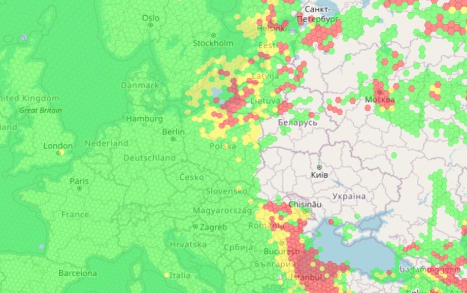
GPS signal interference map
|
gpsjam.org / gpsjam.org
What is the scale in Eastern Europe? Along the Baltic and On the EU eastern flank from 2024 you can see ankle incident growth. Estonia and Finland have numerous difficulties, and the material of the SVT website quoted by ERR spoke about the impact of interference up to 85 percent. flights in the region.
Finnair in April 2024 temporarily suspended the flights to Tartu, and then resumed them thanks to the approaches based on DME, not requiring GPS. Three airports in Eastern Finland (Joensuu, Savonlinna, Lappeenrant) restored grounds as “Plan B”. Lithuania reported in June 2025. over 1000 events – 22 times more than a year agowhich is confirmed by EU messages and analyzes. In March 2024, during a flight near Königsberg GPS, he was disturbed on a plane with the then British defense minister Shapps.
Read also: Falling drones and absurdities on the maps. What happens to GPS on the Baltic Sea?
How to follow real -time interference
The scale of the phenomenon is visualized by the public GPS Jamming: GPSJAM maps, which aggregates accuracy indicators from ADS-B (ADS-B Exchange) transponders, and GPSWISE, using OpenSky data.
These are great tools for observing trends and increased risk placesalthough they are not always a causal proof of a specific attack – interpretation requires caution and comparison with reports.
Whether GPS drowning threatens flight safety
From the point of view of aviation safety GPS/GNSS interference increases the load on pilots and controllers and promote delays and redirectsbut civil transport is based on redundancy. The mentioned INS, radiopomoce and procedures independent of satellites allow you to continue operations.
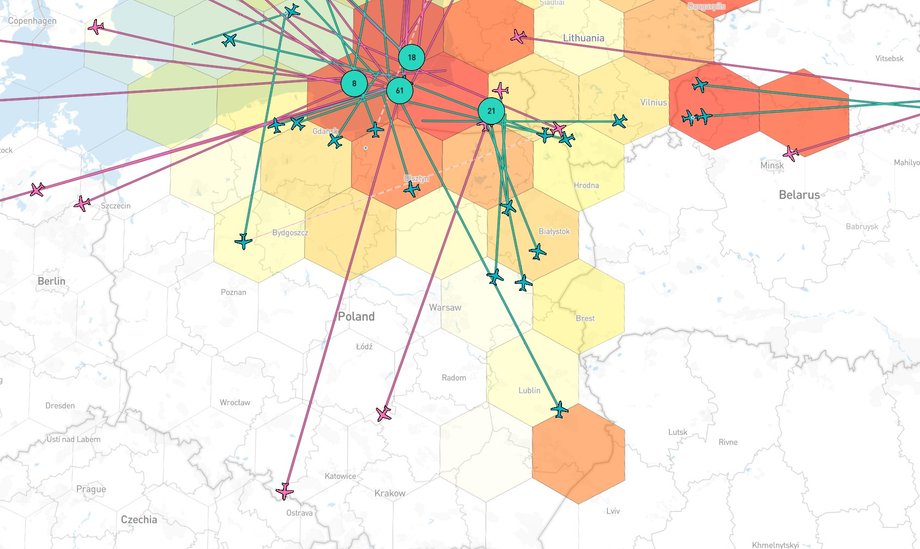
Small GPS signal interference (Polish area)
|
GPSWISE / GPSWISE
The practice of Finnair and Finnish airports showed that the rapid strengthening of DME approach (instrumental approach procedures based on radiopomoca distance measuring equipment) and crew training stabilize the risk to an acceptable level. In June 2025, Easa and IATA announced an action plan (better reporting, monitoring, preparation of alternative procedures), and the American administration in its Safo Bulletin recommended operational activities for carriers.
See also: The Russian attack disrupted the flight of Urszula von der Leyen. The chairwoman of the EC landed without GPS
What Europe does: OSNMA, Coordination and detection with orbit
In 2025, thirteen EU countries called the commission to respond to GNSS interference jointly, indicating the need to implement services resistant to interference, better exchange of civil and military data and accelerate activities.
The Galileo program has launched the OSNMA (Open Service Navigation Message Authentication) service, i.e. authentication of navigation messages that do not eliminate jamming, but hinders effective spoofing. At the same time, there is a discussion about the additional ability to detect disturbances from the low orbit (Leo), which are to improve detection and attribution.
Outside Europe: Red Sea and global effects
GNSS interference also affects strategic sea routes. According to Bloomberg, in June 2025, maritime services and analytical companies reported nearly 1,000 ships a day with navigation problems in the vicinity of the Strait of the Ormuz, and A collision of tankers was recorded in the region, where Jamming was considered as a possible factor.
The Red Sea and the Bay of Oman have an increase in spoofing and jamming, which explicitly translates into operational risk and delays.
What the Plovdiv 2025 incident teaches us
Conflicting relationships arose around the approach to the airport in Płowdiv. The media and some officials talked about the intentional Jamminng related to Russia, while the Bulgarian authorities soothed the message after a few days, indicating the lack of proof of “extended” disturbance. The consensus is that GNSS problems actually occurred. This is a case that shows the growing political burden of technical interference and the need for better detection and transparent reporting.
How to protect yourself? For aviation operators, the most important are training and procedures in the event of losing GNSSuse of alternative approaches (DME/VOR/ILS), current maps of risk zones and current administration newsletters. Airports and space managing ports should maintain radioporative efficiency and consider local complementary systems. Armators and offshore operators should implement the fusion of sensors (GNSS + Insparts + Optics), monitor applications, and in periods of increased risk apply precautionary navigation principles.
Companies with terrestrial fleets and commercial drone operators should have an anomaly detection policy (e.g. sudden “positions” of positions) and a plan to switch to alternative location methods. OSNMA can reduce the risk of spoofing today where the hardware and software support it.
Check also: Poland is measured by GPS signal interference. Huge risk
Is Jammer GPS legal in Poland
NO. The Office of Electronic Communications directly indicates that the jamming devices cannot meet the requirements of conformity and It is not possible to legally marketing or civil use in Poland and EU. The Office of Electronic Communications also warns against real threats to security that such devices cause.
GPS strawing – whether jamming or spofing – has become an element of everyday operational risk. Europe reacts, from coordination plans to the implementation of OSNM and considering sensors on Leo. At the same time, industries learn to function in new normality – redundancy, procedures and better monitoring reduce risk, but do not eliminate delays and costs.
FAQ – popular questions and answers
1. Does GPS drowning threaten flight safety?
Increases the load on pilots and can cause redirects, although civil aviation is based on redundancy (INS, DME/VOR/ILS) and procedures. Easa and American administration publish guidelines limiting operational risk.
2. What is the difference between jamming and spoofing?
Jamming blocks the reception of the satellite signal stronger radio emission, while SPOOFING suggests false position/time to the receiver – OSNMA in Galileo helps to detect spoofing, but does not neutralize jamming.
3. Where are the GNSS interference most often now?
Along the eastern flank of NATO (Baltic, Finland, Lithuania), on the Black Sea and on strategic maritime trails, especially in the area of the Strait of Ormuz and the Red Sea.
4. Can you legally buy and use Jammer GPS in Poland?
NO. According to the position of the Office of Electronic Communications, such devices do not meet the requirements and cannot be legally placed on the market or civilized.
5. How to track real -time interference?
You can use GPSJAM (aggregations with ADS-B Exchange) and GPSWISE (OpenSky data), remembering that these are observation tools and should be combined with official air or sea warnings.
Author: Grzegorz Kubera, Business Insider Polska journalist