Researchers have mapped all the roads in the Roman Empire for the first time, and the result is impressive

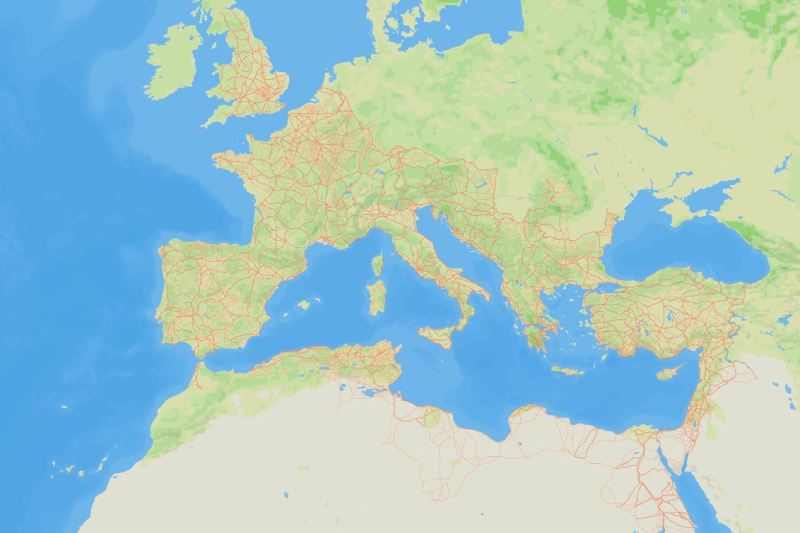
The roads of the Roman Empire mapped within the Itiner-e project, PHOTO: Screenshot from the Itiner-e website
They say all roads lead to Rome, but how many Roman roads were there, really? According to recent research, their total length would have been over 110,000 kilometers longer than previously thought, reports Gizmodo.
Researchers have presented Itiner-e, a new high-resolution digital dataset and road map of the Roman Empire around 150 AD. A team of researchers used archaeological and historical records, topographic maps and satellite images to create this colossus, which maps 299,171 km of roads over an area of nearly 4,000,000 km².
“The road system of the Roman Empire was essential for organizing the movement of people, goods and ideas, and for maintaining imperial control. Yet it remained incompletely mapped and poorly integrated across sources, despite centuries of research,” wrote the authors of the study published Thursday in the journal Nature.
They describe Itiner-e as “the most detailed and comprehensive open digital dataset of roads in the entire Roman Empire”.
Roads were essential to maintaining a huge empire
When the Roman Empire reached its peak in the 2nd century AD, it encompassed more than 55 million people, from present-day Britain to Egypt and Syria.
The new map reveals 110,616 km of previously unmapped roads. According to the researchers, this increase is due to better coverage of roads in the Iberian Peninsula, Greece and North Africa, as well as the correction of some previously proposed roads, adapting them to the real terrain – for example, winding roads through mountains, not unrealistic straight lines.
“This resource is revolutionary for understanding how mobility shaped connectivity, administration and even disease transmission in the ancient world, but also for studying the evolution of land mobility over millennia in this region,” the researchers said.
What researchers know and don't know
In total, Itiner-e includes 14,769 road sections, of which 34.6% are classified as main roads and 65.4% as secondary roads. What is less impressive is that only 2.7% of the exact locations of these roads are certain; 89.8% are known with less precision, and 7.4% are only theorized.
“This highlights a discrepancy between our knowledge of the existence and location of Roman roads: we know that all the included roads were used at some point during the Roman period, but their exact positions are not certain,” the team members explained. They also added that Itiner-e does not represent how the road network has developed over time.
At its most basic level, Itiner-e offers a new and impressive visual perspective on ancient Roman territories that can illustrate just how well connected the Empire was.
Those who make comparisons with a modern map may even discover some interesting details, such as the fact that the road that connects Bologna, Modena, Parma, Piacenza and Milan today is the same one that connected in 150 AD. the ancient cities of Bononia, Mutina, Parma, Placentia and Mediolanum (the Latin names of the respective settlements).