The route of the Barbara cyclone, which brings extreme weather phenomena in Romania. “It moves quite quickly,” explains meteorologists / how long the episode of weather lasts


Romania is under weather alert, five counties and Bucharest being targeted by a red code warning, valid today, from 21.00. Meteorologists announce record amounts of precipitation, which will be brought by Barbara cyclone. How long will the episode of extreme weather take and what route will it have in Romania? Meteorologists explained to HotNews.
Barbara cyclone will bring large amounts of rainfall in the southeastern area of Romania-from Constanța to Giurgiu, which led to the issuance of a red code of torrential rains and the closing of schools in four counties, including in Bucharest.
“Meteorological speaking, it is a cyclone, that is, a formation of low atmospheric pressure,” said Florinela Georgescu, forecast director of the National Meteorological Administration (ANM), for Hotnews. It wanted to emphasize that this cyclone “is an extratopical one, it should not be confused with tropical, hurricane cyclones and other things. In Romania we have no such thing, because we do not live in tropics.”
Which is the route of the Barbara cyclone. As long as it passes
The Barbara cyclone formed in the Mediterranean, somewhere at the southern border of the Adriatic Sea and has reached above the Black Sea, and then it will go to Crimea and to the east, said the director of ANM, who said that this is the route of the cyclones coming from the Mediterranean.
Thus, the cyclone entered Romania to the south, and after crossing the country will go to Ukraine and Moldova
“The trajectory is southwest, northeast, and in Romania the approach is southern, east and then withdrawal to the East, South-East extremity,” explained for HotNews and Oana Păduraru, ANM meteorologist.
She said that the forecasts show that, within 36 hours, the cyclone passes over Romania. “His move is not very slow, because if it were so-or if there was a blocking to keep it in this area and feed from the Black Sea-the codes would extend and we would not get rid of rains for a long time. But it moves quite quickly, and in 24-36 we will get rid of it.”
When the most intense weather phenomena are expected
Wednesday will be the most severe weather, and in some places it could rain three times above the normal Monday.
Thus, in the weather alert of red code, the meteorologists announce: “In Constanța, Călărași, Ialomița, Giurgiu, Ilfov and in Bucharest, it will rain torrentially and abundantly, (…) and in short intervals or by accumulation there will be water quantities of 80-100 and isolated 120-140.
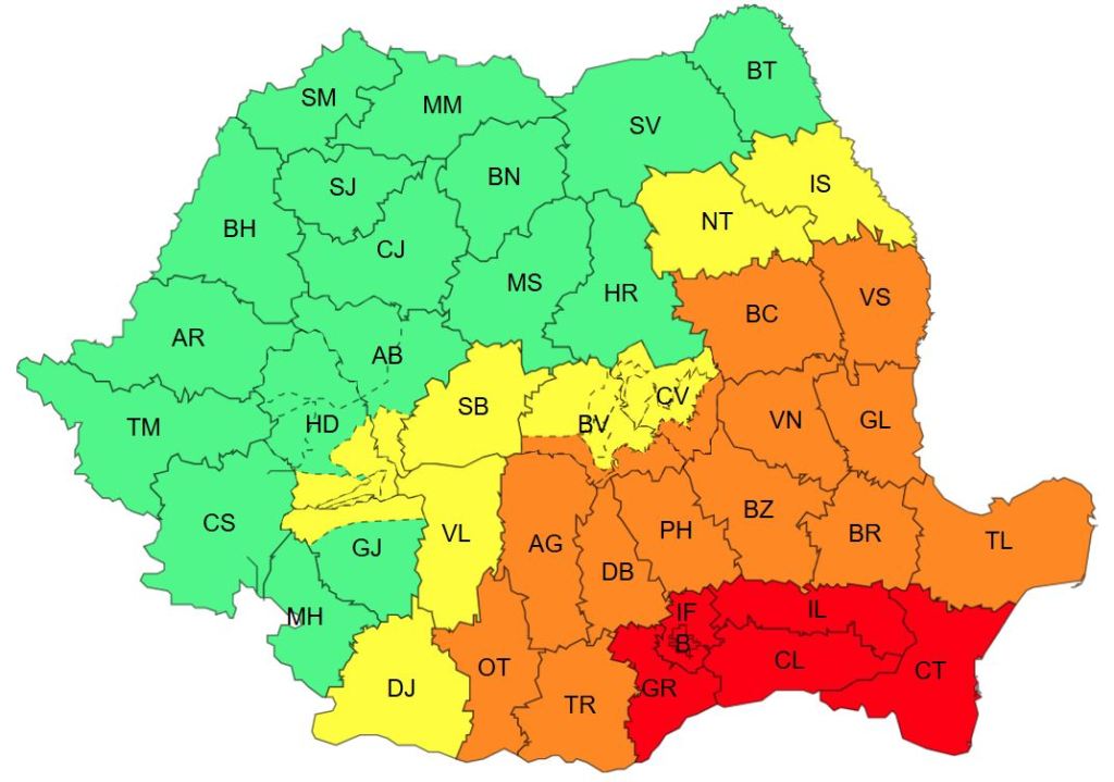
The meteorologist also said that the warning of strong wind, valid from Wednesday at 23, until Thursday at 8 o'clock is a consequence of this cyclone. The warning does not concern the whole country, but the south of Moldova, the east of Muntenia and the Dobrogea region, where gusts of 50-70 km/h are expected.
Forecast, compared to other episodes with torrential rains
How much will it rain in Bucharest during this time? The meteorologist ANM says we could expect 70-90 l/sqm in Bucharest for the entire period of red code.
On average, in Bucharest the precipitations of October total 44 l/sqm. The rainy day in history was October 2, 2005, when at the weather station Baneasa fell 76.6 l/sqm, almost double compared to the monthly average.
Another rainy day was October 1, 2013, the ANM data shows, with 64 l/sqm at Filaret Station.
The rainy October month was in 1972, with a total of 143 l/sqm (more than three times more than normal), at the weather station.
 Red Code: Raed Arafat's request for the population: “Enable RO-Alert messages” / What people have to have in the house