How the killer path of iron gates was tanned. How much money was spent and who made the first navigable channel through the Danube Gorge

129 years ago, the Danube became the main commercial artery opening fantastic development opportunities for all riparian states, especially for Romanians. It is the period when the great Danube ports will know an unprecedented development by opening roads to the West.
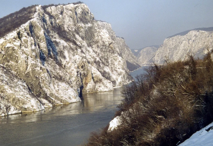
The Wikipedia Photo Danube Defile
Over the millennia, the Danube represented a barrier, but also a vital artery of communication and trade. The huge river with a length of about 3000 kilometers (from Izvorul Bregului) connects two worlds, the West of the East, passing through several capitals in the center, east and south of Europe. The river runs 10 countries: Germany, Austria, Slovakia, Hungary, Croatia, Serbia, Bulgaria, Romania, Republic of Moldova and Ukraine. A few millennia ago, the Danube has shaped the whole landscape and history of human communities. In the Middle Ages it represented a cultural and political barrier, separating the Ottoman, Islamic world. Subsequently, the emergence of nations and the consolidation of modern commercial relations transformed the Danube into a vital commercial route for the economic development of riparian nations, most young states for which trade, especially with the West, became an essential condition of progress.
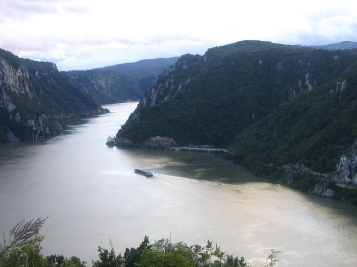
For their part, the central European states were very developed looking for river routes that would open their way to the Black Sea and implicitly to new markets. Until the 19th century, the navigation between the west to the east, especially to the Black Sea, was extremely difficult, if not almost impossible. This is because of the Danube gorge. Especially the area of Big Cazanele, the most well -known and narrow gorge from the Danube entrance from Central Europe to the Balkan area. At boilers, the Danube is only 150 meters wide and a depth of up to 53 meters. The area of the clicles, between Baziaș and Turnu Severin, was full of cataracts, sandy benches and vanners that raised major problems and the most experienced navigators.
This is why the Danubian routes from Central Europe to the Black Sea were largely bypassed. From the middle of the nineteenth century, however, huge efforts to regularize the course and to remove obstacles, to transform the Danube into a waterway from west to east, to the Black Sea. It was a reference event of European commercial history and the first great example of international collaboration to which Romania also took part. It is about the inauguration of the waterway from the Iron Gates in 1896.
The Danube Road from the West to the East
The Danube springs from the Pădurea Neagră Mountains, at the foot of Kandel peak, from the German Rhine. From there, on a distance of almost 3000 kilometers, no less than 10 countries and four capitals. It is the river that crosses the largest number of countries in the world being a path of civilization and trade from ancient times. On the territory of Romania, the lower course of the Danube crosses a distance of 1075 kilometers between Baziaș and Sulina, representing a natural border with Serbia, Bulgaria, Republic of Moldova and Ukraine. For all the peoples who lived on the banks of the Danube, this river represented a trade path. It was related to the North Sea through the Rin-Main-Danube channel, ensuring the transport between the powerful German cities. The Danube was particularly important for the Kingdom of Hungary, connecting it to central European trade, especially German. For the Romanians it was especially a natural barrier to the invaders but also a constant source of food for the inhabitants on its banks, both through the agricultural and fishing potential.
The Danube Clisura photo wikipedia
As a commercial route, the Danube behaved difficulties for the sailors who came from the West and tried to reach the Black Sea. And this mainly because of the Danube gorge. The river first narrows after the island of Moldova Veche, in the Golubac Gorge, on a length of 15 kilometers, with a width of only 230 meters. Following is the second gorge, Vir Gospodin, also 15 kilometers long and which narrows even more, up to 220 meters. After this ordination, the sailors who first crossed the defilers lived with the impression that they escaped danger entering the Donji Milanovac gorge, much wider and connecting between the big boilers and the small boilers. After 19 kilometers, the Danube slid again through a narrow area called the SIP gorge. At the end, however, was the most dangerous area, that of the big boilers, with the narrowest and deeper gorge. The Danube is only 150 meters wide and is full of whirlwinds, sandy benches and cataracts. Here, most ships failed or sank, making the passage to the plains of Wallachia and the open road to the mouths of the Black Sea.
A ship's cemetery, the most dangerous area for navigation
Until the 19th century and the most experienced sailors were afraid for their lives in the Danube defilts, especially in the big boilers. The situation was just as difficult, but also at the mouths of the Danube, in the Sulina area, where there were no navigation rules and there was a bad arrangement of the river and port areas.
“In the middle of the nineteenth century, the Danube navigation was in an extremely difficult situation. The physical geography of the Danube Gas region, with sandy benches, marshy channels or deep sectors, as well as Russia's disinterest in introducing rules of navigation and piloting have fully contributed to the Danube. They were frequent on the Maritime Danube and at the Gura Sulina, as a contemporary, a true cemetery of ships.wrote the university lecturer Doctor Constantin Ardeleanu in “Navigation accidents at the Lower Danube (1856-1914)”. In fact, the wreck of a medieval ship was discovered Tahitótfalu, 30 kilometers north of Budapest.
“The river navigation was very dangerous. The ships with commercial loads that were sailing downstream with the help of the rows and rudder, being very difficult to perform maneuvers. Therefore, accidents were often held.”explained Attila J. Tóth, the representative of the Hungarian officials, for Discovery News.
The first navigable channel to iron gates
The importance of navigation from the west to the east, on the Danube, gained an international interest only after the Crimea war in the mid-19th century. On this occasion, an international regime of navigation on the Danube is established. Basically, the freedom of navigation on the Danube was established. Thus, the European Danube Commission was also established.
“The problem of navigation on the Danube acquires an international interest only after the Crimean War (1853-1856) concluded with the Treaty of Paris. The victory of the Franco-Anglo-Turco-Turkish coalition has brought a new report of forces in Europe, depriving Russia by the means of intervention in the Danube Principalities. For the first time, an international regime of navigation on the Danube is established. According to the provisions of the treaty, the principle of freedom of navigation on the river was instituted. Through this treaty, France and the United Kingdom, winning states, assume the role of guarantees of Europe on the Danube“, States Cam.fl. Cornel Rogozan in the” Danube Navigation regime and its importance for Romania “.
With the independence of Romania in 1878, the arrangement of the area of the Danube defilers, the cloths, became vital. The Ottoman influence was extinguished, and the desire for the hegemony of Russia was kept in rein by the great powers. It was a unique chance of developing the Danube from the west to the east. And this under the conditions in which, in 1857, the British company “Danube and Black Sea Railway Company Ltd.” obtained, from the Ottoman government the concession of the Cernavoda – Constanta and the Maritime Port Constanta. In addition, Romania obtained Dobrogea after 1878 and implicitly the opening to the Black Sea. The Danube became a very important river artery in European trade. There was only to make a navigable channel next to the large boilers. The Habsburgs had noticed this opportunity since 1834 and began a series of arrangements by removing the rocks from the Iron Gates.
The Wikipedia Photo Danube Defile
Only on September 15, 1890, the systematic works of carrying out a waterway in the area of iron gates began. Austro-Hungary, on the territory of which the Banat was then, spent a huge amount for regularizing the Iron Gates sector, around 20 million florins. The first navigable channel from the Iron Gates was inaugurated on September 27, 1896, in the presence of Emperor Franz Joseph. The festive event was held in Orșova and King Carol I of Romania, as well as Alexander I of Serbia, was called. It was the monarchs of the riparian countries, who had mutual interests in the commercial exploitation of the waterway. In fact, in 1884, the Romanian state had bought the port of Constanta and the Cernavoda-Constanța railway, with 16 million lei gold, precisely to achieve the infrastructure necessary for the Danubian trade. It was a crossroads for European and especially Romanian trade.