National roads that give drivers shivers. Extremely spectacular and dangerous at every turn

Three national roads in Romania offer drivers thrills. On the one hand, they cross some of the most spectacular places, but at the same time, they are famous for the problems they have caused over time.
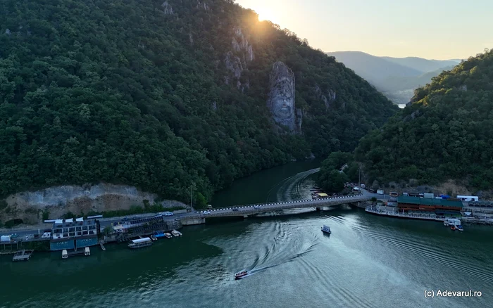
The road through the Danube Boilers, guarded by the Face of Decebal. Photo: Daniel Guță. TRUTH
Landslides, rockfalls, floods and other hazards caused by nature were frequently encountered problems on three of the most spectacular national roads in Romania: DN 7 – Valea Oltului, DN 66 – Defileul Jiului and DN 57 – Clisura Dunării.
The three national roads, with a long history, were built with great efforts, but investments in increasing safety, made over time, could not fully remove the risks that lurk drivers.
The roads carved into the cliffs of the Danube
The Baziaș – Orșova road (DN 57), from the southwest of Romania, accompanies the Danube for almost 140 kilometers, through its most spectacular section, the Danube Gorge (Caraș-Severin and Mehedinți counties). The old road on the bank of the Danube connects the two places through which the armies of Emperor Trajan entered Dacia, crossing the river, in the early years of the 2nd century. One of the routes used by the Romans started near the village of Baziaș, where the Roman fort Lederata had been built, and the other from Orșova, the old city of Dierna.
On the right bank of the Danube, in the Cazanelor area, the Romans built one of the most ingenious ancient roads, about 40 kilometers long. Due to the huge and steep cliffs that bordered the river, for several kilometers the ancient road was carved into the mountain, and in other areas it was suspended, with wooden floors laid on oak beams driven into the rock wall.
“Among the Roman remains that have been preserved to this day, Trajan's Way is undoubtedly one of the grandest. On the Danube road from Drencova to Orșova, on the right bank, we see this masterpiece of Trajan's soldiers, who, on the orders of this emperor, cut the rocks to make a way on the right bank of the Danube. We cannot fully imagine the extraordinary power that these agile workers exerted towards overcoming enormous difficulties, to execute this great work. The rocks rising directly at the water's edge, the workmen had not a palm of earth or stone at their disposal, no ships to cut the stones, and no powder to split them.”the historian Aron Densușianu pointed out, in the magazine Familia (1866).
In the 19th century, the road on the right bank of the Danube was still in use, and on its edges, from place to place, there were ten stone monuments carved into the rock, some called Tabula Traiana, which remembered the efforts made to build the road and paid tribute to the emperor Trajan. The Roman road was flooded in the 1960s, with the hydropower and navigation development of the Danube, but one of the tablets was saved and can still be seen today, after the monument was repositioned on the rocks, 30 meters above its original place.
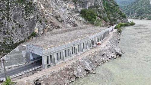
Image 1/5:
Polata de la Berzasca Photo DRDP Timișoara (9) jpg
On the left bank of the Danube, the Baziaș – Orșova road, built in the middle of the 19th century, would compete in spectacularity with “Trajan's Way”. The new route was laid out in similar circumstances, with the support of Count István Széchenyi (1791–1860), Minister of Transport in the Austrian Empire.
The road was laid out together with the works to facilitate navigation on the Danube, carried out in the first part of the 19th century.
“Along the left bank winds, cut into slabs, the Széchényi road. It recalls the first projects, made in 1778 by Captain Lauterer, for the exploitation of the Iron Gates, projects that Széchényi resumed in 1830. Under his direction, through the stone labyrinth of the mountains, the construction of a road close to the water level began; however, the work ceased in year 1841, due to lack of money”informed the magazine Familia, at the end of the 19th century.
The road that rivaled Trajan's Way
The road was built between 1837 and 1840, according to the plans of the engineer Pál Vásárhelyi, and was considered a major work of the era.
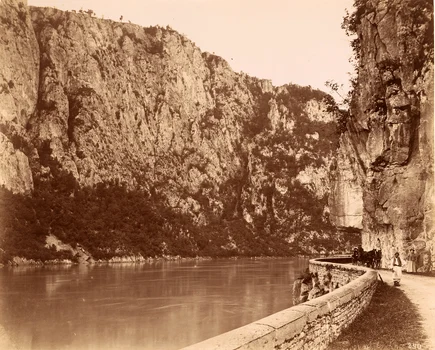
Image 1/15:
The Danube boilers. Photo Geza Hutterer (1864 1917) Museum of Architecture at Berlin Institute of Technology, Germany
“Passing over viaducts, through excavations with many vaults, past the huge walls that rise straight up, the road shows us at every turn of the Danube views of great beauty. It competes in grandeur and boldness with the Roman road on the Serbian bank of the Danube, where its traces can still be seen today. The Roman road, if we consider that those who built it did not have vessels with steam, nor gunpowder, nor machinery, it is a work even greater than Vásárhelyi's”noted the press of the time, at the end of the 19th century.
In the 1960s, the old road was flooded by the Danube in the Cazanel area, and a new road was built on a modified route, along with the development of the Portile de Fier I hydropower plant reservoir. Over time, rockfalls occurred in several places on the road from Cazanele Dunării, and sometimes, because of the rocks, the road remained blocked for days. The most recent serious incident happened in January 2023, in the Berzasca area, when the road was completely blocked due to the collapse of some rocks.
In 2024–2025, an over 100 meter long and 5.5 meter high embankment was built at Berzasca to reduce the risk of rock falls from the slopes.
Almost as spectacular is the Orșova – Drobeta-Turnu Severin road, a road of about 30 kilometers, which passes on the left bank of the Danube, past the Portile de Fier I dam. A lot of viaducts and a few tunnels increase the attractiveness of this route, which was also laid out in the 60s.
Valea Oltului, a road used since ancient times
National Road 7 on the Olt Valley, modernized in the 20th century, crosses the Olt Gorge for almost 50 kilometers, between Turnu Roșu (Sibiu county) and Călimănești (Vâlcea county). The route was used in Antiquity, and the road was redeveloped in the 18th century, according to some historians, after Oltenia came under the rule of the Habsburgs. The route opened in 1722 was known as the Via Carolina, after the name of Emperor Charles VI.
“This road on the edge of Olt was considered in those times as an extraordinary work and was compared to the constructions of the Romans, because, says an inscription from Câineni: even Trajan's bravery stopped here. The difficulties were indeed very great, having to overcome the rocky resistance of the Carpathians and the angry whims of Olt, and the proof is that even today the piece of road between Câineni and the mouth of the Lotru, on a stretching for several kilometers, it is still unfinished”, informed the magazine Familia, in 1890.
The works on the road in Valea Oltului were resumed at the end of the 19th century, and in 1901 the railway from Valea Oltului was also inaugurated. In the 20th century, the road continued to be modernized, and road traffic became more and more intense. It was paved before the Second World War and, although it still kept some sections only paved, in the 1950s it was considered one of the best roads in Romania.
After the war, it was paved over its entire distance, over 100 kilometers, between Sibiu and Râmnicu Vâlcea. Floods often caused flooding in the Olt Gorge, but in the second part of the 20th century their effects diminished, along with the hydropower installations on the Olt River. Instead, rock and rock falls continue to be frequent.
The Jiului gorge, widened with the help of dynamite
The Jiului gorge starts from the edge of the Petroșani municipality, in Hunedoara county, and continues on a winding route, which closely follows the course of the Jiului, towards the south of Romania, until the entrance to the town of Bumbești-Jiu, in Gorj county, located at the exit of the mountains.
The deep valley of the Jiu, which separates the Vâlcan Mountains from the Parâng Mountains, is crossed by the National Road 66 Petroșani – Târgu Jiu, one of the most spectacular roads in Romania. Over the past two centuries, people have made considerable efforts to “tame” the forces of nature in the more than 30 kilometers long gorge. The rocks on the side of the road, which follows the course of the Jiu, were chiseled and dynamited, and the slopes were cemented, tunnelled and covered with nets in many places, to reduce the danger of falling rocks and to make way for the road, as well as the railway.
Falling boulders and trees, some from almost 200 meters above the road, continued to occur frequently and cause casualties, most recently in the fall of 2022, and the risk of accidents could not be completely removed.
In recent years, the modernization works in the Jiului Gorge, on National Road 66, have reconfigured the route, giving it more safety.
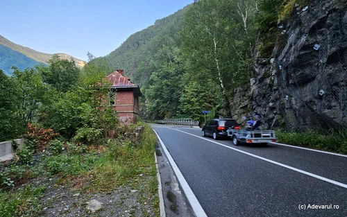
Image 1/16:
Jiului Gorge Photo Daniel Guta THE TRUTH (29) JPG
Bridges and footbridges were rehabilitated, the slopes were reinforced with steel nets in vulnerable areas, metal parapets were installed along the entire length of the road to reduce the risk of cars ending up in the river, some curve areas were widened after the builders had to dynamite parts of the mountains, new bridges were built, giving up some unsafe constructions.
The most sought-after place in the Jiului Gorge is the Lainici Monastery, built and painted two centuries ago. The monastery remained one of the few human settlements on the mountain route. Near it, several rocks were dynamited to set up the road and some parking lots.
Until 1918, the Jiului Gorge represented the border between Transylvania, located in the Austro-Hungarian Empire, and Romania. From the former border in Pasul Surduc, there is still a building over a century old, abandoned on the side of the Petroșani – Târgu Jiu road, between the steep slopes crossed by the Jiu river.